top of page
NAVTOR-logo-strapline-colour.png
P1049989 sRGB_4Kpx 1.jpg
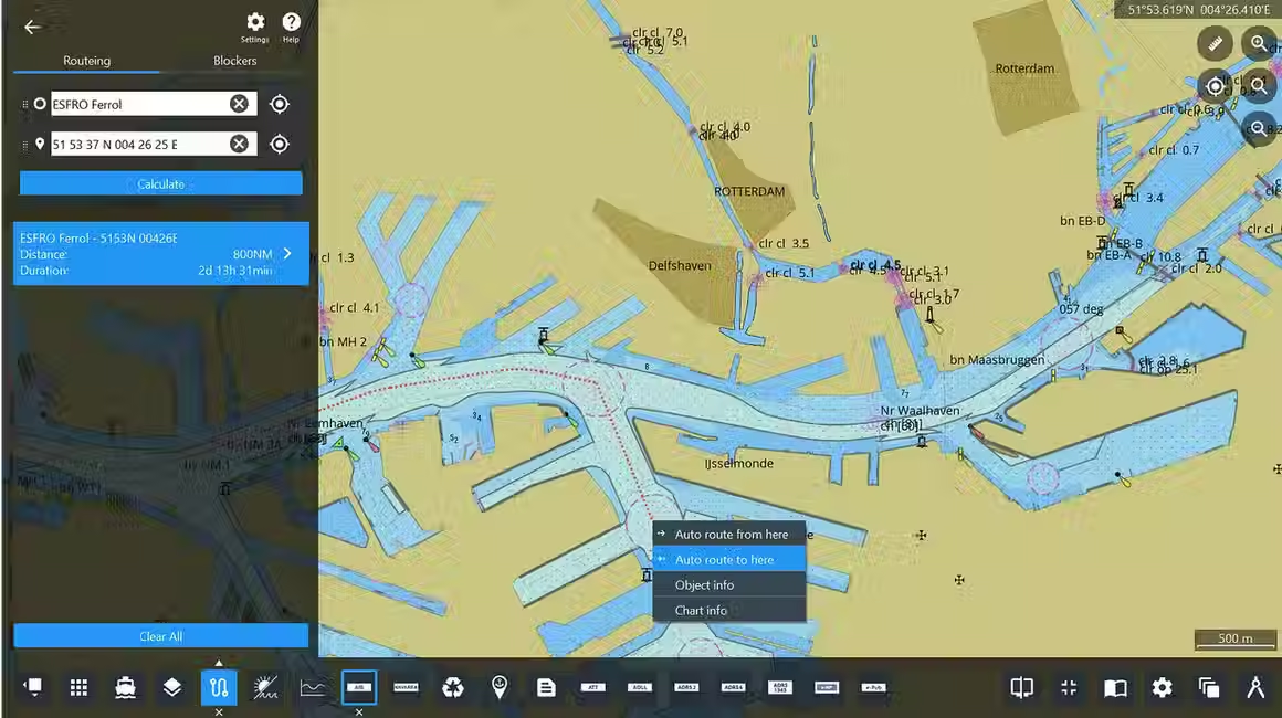
Navstation-monitor-AutoRouteing-1_edited.avif

AUTO ROUTEING

Simply plan your voyage from any position to any position, globally.

Built on NAVTOR’s smart and integrated technology, the new Auto Routeing module will generate a smart route suggestion between two positions.

Get on board for intelligent Auto Routeing.

compass-reflected_edited.png

The next generation of Auto Routeing

The new integrated Auto Routeing module in NavStation prepares a route suggestion in seconds. This quickly provides an overview for distance and duration and it can be used as a foundation for further detailed route planning.


The principle of Auto Routeing is based on the shortest route. Using open waters and routeing along predefined lines in restricted areas, such as coastal waters, Traffic Separation Schemes (TSS), entrances into ports etc.


You can easily edit and compare the route alternatives. 

The Auto Routeing module is fully integrated with the onboard NavStation Route Planning module. 

Auto Routeing features

Blockers 

  • Common straits, TSS, canals etc. can be closed

  • Controls the routeing alternatives

Routeing

  • Shortest route in open waters

  • Along predefined route lines in coastal waters, TSS and entrances into ports


Routeing lines into most terminals in major ports

  • Select a required location in the port and you will get a complete route suggestion, berth to berth. 

ikons_3.png

Auto Routeing to and from any port or any position

The Auto Routeing tool in NavStation lets you generate route suggestions to and from any port, from your own ship position to any position, or a selected position on the map to any position. 

ikons_2.png

Port Database
list search

Departure or arrival ports can be selected directly on the map, or looked up by searching for a port name or UN/LOCODE in the search field that contains all ports from our new port database in NavStation.  

icons_.png

Customise your routeing preferences 

Vessel particulars, cargo type, and safety requirements influence how Auto Routeing calculate the route suggestion for your voyage.

Note: Any route produced by the Auto Routeing module is a SUGGESTION ONLY and  requires further route and passage planning analysis. It is the mariner’s sole responsibility to adjust the route to match the vessel’s characteristics, company policies and regulations; in order to validate the route towards the latest Chart and Publication updates and navigational warnings.

Discover more layers and modules in NavStation

Monitor---NavStation-6-4-Maritime-Security-module.png

Maritime Security Information

tay alert and informed regarding the global threat landscape with comprehensive intelligence data powered by Risk Intelligence.

Navstation-monitor-AutoRouteing-1_edited.avif

Auto Routeing

Simply plan your voyage from any position to any position, globally.

NAVTOR-TimeZones.avif

Data Layers

Paperless and easy access to Time Zones • Load Lines • Chart 1

Port-Data-Gibraltar-.avif

Port Data

Powered by S&P Global

Extended Port Database - Providing you with the most comprehensive port directory.

893d6f_05a295a4fa51453680334c6362153cc1~mv2.avif

AMVER Reporting

Simply saving lives!

NAVTOR has teamed up with the United States Coast Guard (USCG) to integrate AMVER into the NavStation.

Userlayer-monitor-web.avif

User Layers

Add your own icons on top of

any layer in NavStation.

WNI-OSR-monitor- two-routes-web.avif

Weather Routeing

Powered by WNI

Leading the way in weather. High-quality data and best-in-class ship routeing visualisation and optimisation with WNI and NavStation’s unique planning capabilities.

MA-docking-web.avif

Manoeuvring Assistant

Find your way through heavy traffic and complex berthing operations with NAVTOR’s unique Manoeuvring Assistant module.

NavStation-Passage-plan_UKC_MONITOR.avif

Passage Planning

Our award-winning Passage Planning module transforms administration for bridge officers, automating processes, easing workloads and opening up a new age of efficiency, safety and simplicity.

EnvironmentalRegulations-monitor-web.avif

Environmental Regulations

Complete Compliance

With environmental regulations increasing in stringency and complexity, access to the right data, at the right time, protects you from paying the price of non-compliance.

NavArea-Warnings.avif

NAVAREA Warnings

Global coverage of NAVAREA Warning (world-wide service) updated on a daily basis.

WeatherOverlay- Monitor-isolated-web.avif

Weather Overlay

NAVTOR has teamed up with Weathernews Inc (WNI) to deliver the market's most comprehensive, high quality and up to date weather data. 

e-publication-reader.png

e-Publication Reader

Read all about it.

Every maritime publication you need, just a few clicks away. NavStation's e-Publication Reader Module is a complete management tool – easy, compliant and always up to date.

AENP-laptop-web.avif

AENP

Seamlessly register, access, licence and update all AENPs from within the software.

ADP-laptop-web.avif

ADP

Displayed graphically over ENC data in their geographic location.

2020-04-17 15_32_06-NavStation - AIO 2.avif

AIO

ADMIRALTY Information Overlay - displayed over ENCs in ECDIS and other chart display systems for additional information during passage planning.

Routeplanning-monitor.avif

Route Planning

Easy and enhanced route planning.

All the information you need available with module overlays. Easily import routes to and from ECDIS. 

AIO-1-Monitor-web.avif

ENC

All the most trusted charts and publications for every conceivable voyage, delivered when and where you need them.

bottom of page